
As central Indiana shifts into autumn, global weather patterns are setting the stage for what lies ahead. At the heart of these shifts is a powerful natural phenomenon: a “Super El Niño.”
According to Bret Walts, senior long-range meteorologist at BAMWX, global ocean patterns play a foundational role in shaping seasonal trends across the Midwest.
“El Niño is the biggest global pattern driver when it comes to weather in the world,” Walts said. “There’s nothing else that’s more impactful to our weather. And when I say that, I don’t necessarily mean that it’s going to impact the storm today or tomorrow, but it affects how frequently we get certain patterns.”
Understanding El Niño and La Niña
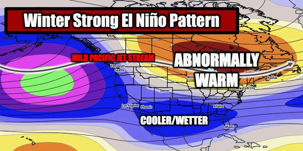
At its core, El Niño refers to a periodic warming of ocean temperatures in the equatorial Pacific Ocean.
“An El Niño is, very simply put, warmer than normal ocean waters that develop in the equatorial Pacific off the coast of South America,” Walts explained. “You get a shift in winds, and the very warm waters out towards Indonesia actually move eastward as you get westerly winds … near South America.”
These sea surface temperatures vary in intensity, ranging from weak shifts to extreme events.
“To put that into some context, this year we’re looking like we’re going to be 3 degrees or more Celsius warmer than normal,” Walts said. “That is extreme … and that’s where the ‘super’ comes in. It’s all the same process, but the super versus just your traditional El Niño, it’s just a difference in how intense the event is.”
By contrast, La Niña acts as the inverse mechanism within a naturally occurring planetary cycle, pushing cooler-than-normal ocean waters near South America via easterly winds.
“El Niño and La Niña, I would call it the way that the atmosphere tries to balance itself out,” Walts noted. “They’re naturally occurring. They go back and forth. They normally last a year or two at a time … It’s just a pattern that has happened and fluctuated for as long as we have been recording weather information.”
Summer Impacts Across Central Indiana
The impacts of this current Super El Niño cycle already manifested across the region throughout the summer months.
“What El Niño does in the summer is it helps amplify the monsoon in the Southwest,” Walts said. “So you’ve got more moisture streaming up into portions of the Desert Southwest … As a result, we get extra moisture, and we typically in that type of pattern get moisture from the Gulf as well.”
That surge in atmospheric moisture directly contributed to heavy rainfall and severe localized flooding events late in the summer.
“I think that the El Niño was directly related to how extreme the flooding issues became back in August,” Walts said. “That monsoonal flow and the jet stream was a big part of it … We also had some cooler air stuck up in Canada, and when you get cooler air north and warmer air south, you get a lot of converging winds, and you typically get more enhanced precipitation.”
Winter Outlook: Mild Temperatures, Reduced Snowfall
As winter approaches, long-range historical data indicates a clear and consistent signal for central Indiana during strong El Niño cycles.
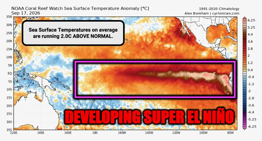
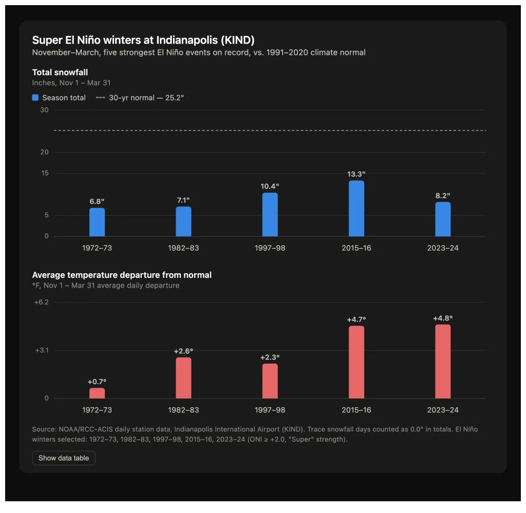
“Super El Niño and even just strong El Niño years in general have a very consistent pattern, typically, as we head into winter,” Walts said. “There’s not a whole lot of volatility in these years. And what typically happens is we get much warmer patterns, especially to start out the season. December and January tend to be very warm.”
Historical records for central Indiana show a strong correlation between these atmospheric conditions and below-average snowfall totals.
“In prior history, all of our different strong to super El Niño years are typically among some of the least snowy that we’ve seen,” Walts said. “We average out, in a lot of cases, nearly half of the normal snowfall. And so they tend to be very mild and rather inactive winters when it comes to snow.”
Walts noted that the jet stream plays a pivotal role in keeping severe Arctic blasts at bay by bringing milder air directly from the Pacific Ocean.
“Especially December, looking back historically, there have been some really warm Decembers, where we even have days that get up into the 60s in central Indiana,” Walts said. “You can get a very slow start to the season … You still struggle to get those big cold air blasts.”
For residents hoping to avoid severe ice storms and frequent polar vortex outbreaks, the pattern offers relief, shifting primary ice storm risks farther east toward the Appalachian Mountains. Late winter offers the best chance for any temporary shifts toward seasonal cold.
“If I were to look back and say if there’s one month that could offer up at least a little more cold, it would probably be late in the season in February,” Walts said. “We’ll get some snow … But it’s probably going to be a lot less frequent.”
Looking Ahead to Spring
While winter is expected to remain generally mild, post-El Niño springs tend to feature a slower transition rather than immediate, violent severe weather outbreaks.
“Post-El Niño springs can be somewhat active, but aren’t always necessarily as active from a severe weather standpoint as coming out of La Niña winters,” Walts explained. “It’s a trade-off … Sometimes these El Niño springs, it can be slower to get into spring. It can be a little bit wetter, a little bit cooler, longer, but not as much severe weather.”
Passion for Seasonal Forecasting
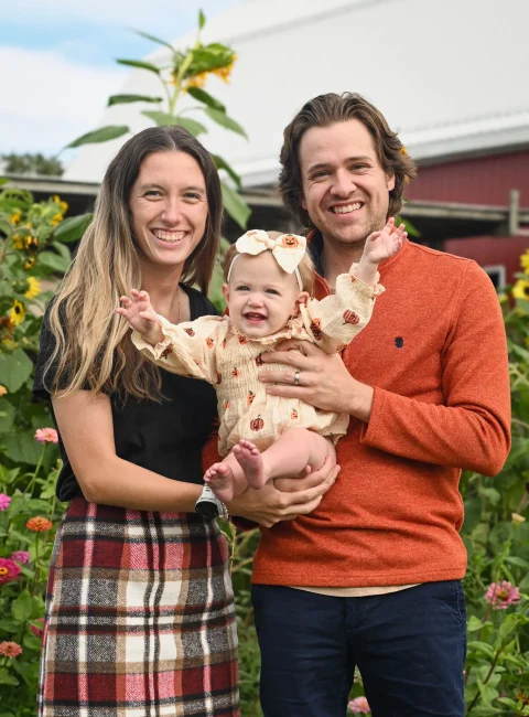
For Walts — a Southern Indiana native and Indiana University graduate who joined BAMWX in 2017 — analyzing complex global patterns remains a lifelong passion.
“Weather has always been a huge passion of mine, especially winter,” Walts said. “That’s one of the things that attracted me to BAM, because they did a lot more of the seasonal weather forecasting … understanding how all of these bigger global patterns affect our weather. It was a natural fit.”
Don’t get caught off guard. Get full forecasts and updates by subscribing at bamwx.com.